Protected zones in context: Exploring the complexity of armed conflicts and their impacts on the protection of biodiversity
Share this article

Protected areas safeguard biodiversity of global ecological importance, even throughout armed conflicts. The International Law Commission's Principles on Protection of the Environment in Relation to Armed Conflicts propose that certain ecologically important areas could be designated as protected zones during armed conflicts. This article uses a geospatial analysis of armed conflicts and Key Biodiversity Areas and three case studies to inform recommendations on how the protection of ecologically important areas could be enhanced through visibility, local actors and international stakeholders as part of a broader interpretation of a protected zone.
* Elaine (Lan Yin) Hsiao is Assistant Professor, School of Peace and Conflict Studies, Kent State University, Kent, OH, United States, and Chair of the Theme on Environment and Peace, Commission on Environmental, Economic and Social Policy, International Union for Conservation of Nature; Adrian Garside is Visiting Research Fellow, Department of War Studies, King’s College London, UK, and Lecturer, Masters’ Program, Gorongosa National Park, Mozambique; Doug Weir is Research and Policy Director, Conflict and Environment Observatory, Hebden Bridge, UK, and Visiting Research Fellow, Department of Geography, King’s College London, UK; and Andrew J. Plumptre is Head of Key Biodiversity Areas Secretariat, based at BirdLife International, Cambridge, UK
Corresponding author: Elaine (Lan Yin) Hsiao, email: ehsiao1@kent.edu
Funding for Andrew J. Plumptre is provided by the KBA Partnership and the Bezos Earth Fund.
Key Biodiversity Areas and armed conflict: Aligning protected area and protected zone policies
The end of 2022 marked an important moment for international environmental and humanitarian law, with the adoption of principles and policies intended to protect the environment from some of the worst of human harms – in particular, from environmental degradation, biodiversity loss and the effects of climate change, in addition to the violence of armed conflict and warfare. On 7 December 2022, the United Nations (UN) General Assembly adopted twenty-seven Principles on Protection of the Environment in Relation to Armed Conflicts (PERAC Principles) recommended by the International Law Commission (ILC).1 Shortly after, on 18 December 2022, the 15th Conference of Parties to the UN Convention on Biological Diversity (CBD) adopted the Kunming-Montreal Global Biodiversity Framework to halt and reverse biodiversity loss.2 Climate change, pollution and biodiversity loss are considered the “Triple Planetary Crisis” by the UN Framework Convention on Climate Change.3 These codifications of legal principles and conservation objectives intersect in the recognition of territory- or area-based protection of the natural environment through what the ILC refers to as “protected zones” and the CBD calls “protected areas” and “other effective area-based conservation measures” (OECMs). OECMs encompass different effective management options that support conservation objectives besides protected areas, such as private ownership of land and community reserves.
Places of ecological and cultural importance have long been designated as protected areas (e.g., elephant sanctuaries in India in the fourth century BC, or imperial hunting reserves in China in the third century BC)4 and now provide a global framework for safeguarding the world's biodiversity, as well as supporting climate mitigation strategies and the protection of human communities and cultural sites. There are various categories and types of protected areas (e.g., national parks, marine reserves), but they are all linked with a common objective of conserving nature.5 Over the last century, it has also been argued that certain protected areas should be places of peace (i.e., peace parks), protected areas dedicated to peaceful relations and cooperation in addition to biodiversity conservation.6 The two PERAC Principles on protected zones are the latest incarnation of an idea that emerged in the 1970s and which has again come to prominence in the context of increased attention on the environmental dimensions of armed conflicts and the accelerating crisis of global biodiversity loss.
The PERAC Principles provide that “States should designate, by agreement or otherwise, areas of environmental importance as protected zones in the event of an armed conflict, including where those areas are of cultural importance” (Principle 4), and that these protected zones “shall be protected against any attack, except insofar as [they contain] a military objective”, with the possibility that additional protections may also be negotiated (Principle 18).7 In its commentaries to the PERAC Principles, the ILC suggests at least two types of protected areas that could qualify as protected zones: World Heritage Sites and internationally agreed protected areas.8
While the focus is often on the physical damage that protected areas can suffer during conflicts, the relationships between conflicts and ecologically important areas can be more complex. In international armed conflicts, transboundary or border-adjacent protected areas can be part of a disputed international border and may be securitized to enforce territoriality, or they can be afflicted by cross-border incursions and occupied in annexations. Even in non-international armed conflicts, protected areas in a neighbouring country can be affected by spillover activities between armed groups or become throughways for displaced peoples. Directly or indirectly, protected areas can also be impacted by secondary effects of armed conflict, such as shifts in conflict economies that may increase pressure on natural resources and decrease resources for conservation, or as emphasized in this article, the displacement and temporary or long-term resettlement of people. In line with the PERAC Principles’ temporal framework, this article identifies approaches that may be taken before and during, as well as after, armed conflict.
An important standard that protected areas and OECMs should meet in order to be considered for designation as a protected zone, and thus benefit from enhanced protection during different stages of armed conflict, is as “areas of environmental importance …, including where those areas are of cultural importance”.9 Key Biodiversity Areas (KBAs) are “sites of importance for the global persistence of biodiversity”10 and can be culturally important, especially at the national level. KBAs are identified at country level by States using a set of eleven criteria, published in an International Union for Conservation of Nature (IUCN) Global Standard, applied to data that each country holds on its biodiversity.11 KBA criteria are used to identify that a site contains a globally significant proportion of the population of a species or extent of an ecosystem.12 KBAs can become protected areas or be conserved through OECMs, and the proportion of KBAs covered by protected areas or OECMs is an indicator for the CBD and the Sustainable Development Goals.
This article is informed by a geospatial analysis overlaying data on the location of armed conflict events with data from the World Database of Key Biodiversity Areas (WDKBA) in order to analyze the global extent of armed conflict impacts on these sites. More specific empirical analyses within the article highlight the intersection and impact of armed conflicts in specific protected areas in the Greater Virunga Landscape (in the Democratic Republic of the Congo (DRC), Rwanda and Uganda), South Sudan and Ukraine. Drawing from these case studies, we offer a set of recommendations addressing (1) protection through visibility, (2) protection through local actors, and (3) protection through international stakeholders. These findings will support the work of those wishing to develop the concept of protected zones further and to build on the emerging literature on the recognition of protected areas as protected zones.13
Armed conflicts and the environment: Understanding impacts on KBAs
Understanding the impacts of armed conflict on the environment from the perspective of biodiversity, which then defines areas of conservation importance such as KBAs, reveals an area of study that would benefit from some nuance or differentiation from other related literatures.14 This topic should not be confused with broader studies in armed conflict and the environment or environmental security, which often examine environmental factors as contributing to tensions that may lead to conflict, whether over competition for control of natural resources for economic advantage or as scarcity-driven conflict.15 While broader environmental security scholarship does help to decipher the motivation for control over areas where resources exist and how their associated trade routes play a part in armed conflicts, it leaves out the impacts of those activities on biodiversity and natural habitats. In other research on the broader environmental impacts of conflict cycles (military or humanitarian), which have led to calls for “greening the Blue Helmets” and the military industry, the focus again diverts from biodiversity conservation and often emphasizes sustainable technologies (e.g., renewable energy and waste management).16
While all of the above can affect protected areas and OECMs, this study focuses on the current literature on the impacts of armed conflicts on biodiversity, in areas of global significance for biodiversity (KBAs), in order to inform the development of effective measures for implementing PERAC Principles 4 and 18 in protected zones. With a brief examination of how different types of conflict have differing impacts on biodiversity, a key factor that emerges is how armed conflict affects the management of protected areas and not just biodiversity alone.
Direct and indirect impacts on biodiversity and KBAs
Central to various analyses are definitions of “direct” and “indirect” impacts of warfare on biodiversity, sometimes defined respectively as what occurs on the battlefield as opposed to that which occurs away from the battlefield but is a consequence of armed conflict.17 Research that has examined a broad range of impacts worldwide (but with a focus on Africa, Asia and the Middle-East) shows that there are twice as many impacts18 related to non-military consequences of armed conflict (often indirect) as there are to military activities (both direct and indirect), although there are grey areas as to what constitutes military activity, and this requires further clarification.19 Conflicts do not just impact biodiversity, putting pressure on wildlife and habitats; they also impact the management of protected areas and those responsible for keeping them safe and regulated. Gaynor et al. highlight complex pathways that link conflict to wildlife habitats and populations,20 drawing out the need to better understand how and why the practice of war negatively affects both biodiversity and the practice of protected area management.
As the mapping analysis that follows shows, there are frequent instances of camps for internally displaced persons (IDPs) and refugees being established in the vicinity of KBAs, and as the case studies illustrate, places like this can lead to further environmental harm, such as the subsequent depletion of forests for cooking fuel and pressure on wildlife for bushmeat.21 It could be argued that many of these threats emerge from complex issues concerning civilian actions, and thus that they often lie beyond the remit of international humanitarian law. They can also occur at different stages of the cycle of conflict.
Changes in warfare: Differentiating types of armed conflict, actors and activities
An examination of different types of armed conflict, actors and activities can highlight the causation of a broad spectrum of impacts on biodiversity that differ in time, space and intensity. An agreed multi-disciplinary framework for analysis could bring much-needed clarity and shed light on what might be done to enhance biodiversity protection through protected zones in both international and non-international armed conflicts. Most research on the impacts of armed conflicts on protected areas has focused on the global South because of its stereotypically iconic biodiversity and protected areas, mixed with ongoing histories of wars of liberation or civil conflicts in its post-independence era. The proliferation of small arms and light weapons from this era has become a major issue in relation to wildlife poaching during and after conflict.22 Some literature notes that conflict “plays out in remote areas”,23 but there is less evidence of this in contemporary conflicts, where the emphasis is on securing political (and therefore urban) population centres and infrastructure, the latter of which may be in peripheral areas.24 More recent armed conflicts have brought new technology such as drones to the battlefield, which now spans low- to high-intensity warfare. High-intensity warfare backed with technology can bring a scale of destruction to biodiversity that is very different to bush wars where the AK47 dominated. Responses aimed at protecting biodiversity need to be tailored to address these myriad situations.
Asymmetric warfare presents other impacts. In the western Sahel, non-State armed groups utilize the cover provided by remote protected areas and disenfranchised human populations living in these rural and often peripheral areas to provide secure bases and recruitment.25 This creates significant challenges for national armies and international coalitions with regard to preventing protected area personnel from becoming embroiled in the conflict, a risk that might compromise the role of park rangers as “neutral actors”, as is required to sustain protected zone status.26 The effects of this type of asymmetric conflict on biodiversity are yet to be understood, although loss of tourism revenue and thus conservation financing is certainly one.
The reduction in patronage-based military equipment after the Cold War drove armies and non-State armed groups to secure their military funding from natural resource extraction, with a negative impact on wildlife and protected areas that lasts long after the formal cessation of hostilities. This continued through the use of proxy wars and the emergence of new patronages, agreements that are often dependant on the provision of natural resources. Conflict economies premised on natural resource extraction have knock-on effects on protected area management. In some cases, the resource can be so vital that a KBA is targeted, as is often the case with securing oil fields. As another example, Zimbabwean soldiers sent to contain the violence in Mozambique's civil war have been accused of depleting the elephant population in Gorongosa National Park for ivory.27 The greatest threat to KBAs in armed conflict can come from biodiversity loss through, for example, the illicit trade of timber, mining of minerals or hunting of wildlife. There are nuances to this issue between international armed conflicts, where one State plunders another's resources for its own gain, and non-international armed conflicts; in both cases, however, the extraction is often a criminalized activity that sustains armed conflict. A key point is that the threat which such extraction represents to biodiversity and protected area management often changes throughout the cycle of these conflicts. As the insecurity presented by an armed conflict subsides, and prior to the establishment of good governance, conditions exist that can be associated with high levels of resource extraction.28 Wartime resource exploitation undermines the economic development that can be promoted in post-conflict recovery and reconstruction.
Armed conflict and conservation actors
By their nature and for their own protection, biodiversity and protected areas often exist in more remote areas, not in urban centres. Theorists of modern warfare discuss wars “amongst the people”29 and in cities in the “urbanised, networked littorals”.30 In this context, the role, recruitment and employment of conservation actors, in particular protected area rangers, needs careful examination. For various reasons, rangers are often recruited from local communities in proximity to the protected area; this is particularly the case when upholding principles of equity and inclusion in local conservation governance. This can put park staff at odds with the cities/urban centres and their governments – for example, in the civil wars on the African continent that have been fought over “government-held urban centres with rebels controlling the bush”.31 In South Sudan, at times when civil conflicts escalate, park rangers have allegedly abandoned their posts to rejoin armed groups on different sides of the conflict, sometimes under threats or other pressures, including ethnic or identity-based affiliations.32
Aside from direct conflict engagement, protected area staff may have militarized or paramilitary roles, may use military equipment, and are often aligned with or perceived as an institution in the national security sector.33 In international armed conflicts, personnel and equipment intended for conservation activities may be utilized to fight the war. In Ukraine, for example, the vehicles, weapons and equipment used by park rangers have allegedly been consumed by the national war effort, to which many rangers have also turned.34 In non-international armed conflicts, protected area staff can find themselves on an opposing side to the State government, and conservation management risks becoming embroiled in political conflict. Closer examination is needed in areas of asymmetric conflict, such as in the western Sahel, where wildlife rangers may be lured into taking sides in a political conflict in the process of protecting biodiversity. In the DRC, it has been argued that non-State armed groups seize control of protected areas, many of which are KBAs, partly to exercise and demonstrate their authority in contrast to what may be perceived as a corrupted or failed State.35 In order to sustain conservation activities in those territories, protected area authorities have at times negotiated with non-State armed actors, distinguishing themselves from the rest of the State apparatus.36
There is a history of and need for those with protected area management experience to be involved in the negotiation of protected zones. These individuals bring knowledge of politics on the ground in and around the KBAs or protected areas, and of the dynamics of territorial and natural resource control. A perspective from the protected zone outwards, rather than the view from the city, might prevent a protected zone designation that facilitates a military-led operation. It can also identify the utility of protected area management in post-conflict peacebuilding.
Funding for conservation is another area that lacks consistency, except for the recognition that there is a funding gap. Many countries, especially those facing instability and prone to conflict, are reliant on international donor support to maintain the management of biodiversity areas. The World Bank's Collaborative Management Partnership Toolkit provides some structure for models of collaboration between conservation organizations and national governments for the management of protected areas.37 It draws from research focused on Africa, where funding is traditionally delivered through international conservation organizations co-managing protected areas in partnership with the government. When armed conflict starts, these relationships become fragile for a variety of reasons, including association with government rangers when there are concerns over that government's legitimacy; issues of staff safety and security; and the imposition of highly restrictive funding measures. As a result, international conservation organizations have often departed or frozen programming despite the needs of local staff who may remain. New models for funding the protection of biodiversity and the management of protected areas, from public–private partnerships to private financing or statutory government donors and charities, bring different opportunities and risks for tackling conservation in conflict-affected KBAs.
In non-international armed conflicts, where a national government may lose legitimacy and does not have control of protected areas, the suitability of co-management should be reviewed carefully. This is not just a funding problem: there is much bigger political complexity for statutory donors to be aware of. As stated above, wildlife rangers may be caught up institutionally in the security sector in conflicts where actors on all sides are accused of committing crimes against humanity. Protecting biodiversity during armed conflict requires sustained commitments to conflict-sensitive engagement.
Analysis of conflict events in and near KBAs
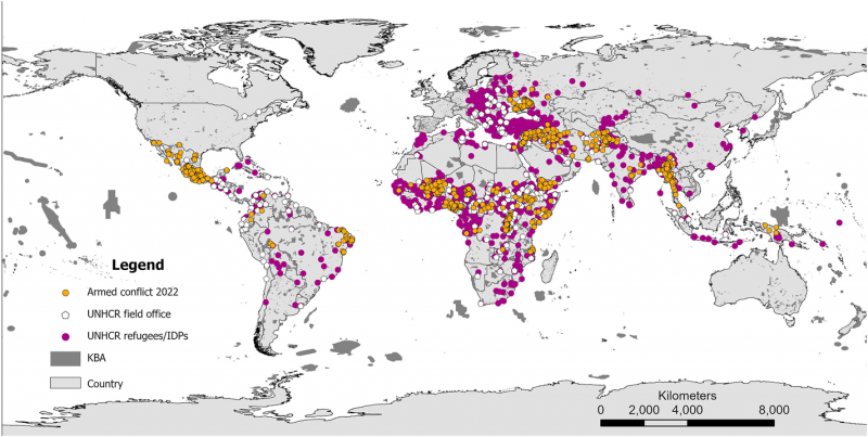
While most of the literature on the environmental impacts of international or non-international armed conflict focuses on the effects of conflict activities, as noted above, human displacement and civilian coping strategies can be an indirect driver of biodiversity loss in protected areas. In order to better understand the potential impacts of conflict hostilities versus conflict displacement on KBAs, this section analyzes the locations of KBAs and conflict events together with data on the location of activities of the Office of the UN High Commissioner for Refugees (UNHCR) and forcibly displaced peoples utilizing four data sets for 2022:
-
Uppsala Conflict Data Program (UCDP) Georeferenced Event Dataset (GED) on armed conflict events (https://ucdp.uu.se/downloads/) – selecting only location data that was related to an exact location (671 sites).
-
UNHCR refugee and IDP locations (https://data.unhcr.org/en/geoservices/) – UNHCR People of Concern data, selecting “refugee” and “IDP”.
-
UNHCR field offices and field unit locations (https://data.unhcr.org/en/geoservices/) – UNHCR Presence data, selecting only “field office” and “field unit”.
-
KBA locations (www.keybiodiversityareas.org).
Each of the first three data sets is geolocated with a latitude and longitude coordinate reference as a point location. The UCDP's definition of an armed conflict event is “[a]n incident where armed force was used by an organised actor against another organized actor, or against civilians, resulting in at least 1 direct death at a specific location and a specific date”.38 UNHCR provides locations of various aspects of its interventions, and we selected the locations of field offices and field units as a measure of an intervention over which it has some control. The UNHCR People of Concern database records several groups, and we selected only refugee and IDP locations. Only events and locations in 2022 were used in the analysis. The KBA data consist of mapped polygon shapefiles stored in the WDKBA.39 This analysis is important in understanding the actual threats to KBAs in terms of temporality – during conflict as opposed to post-conflict – both inside and outside KBAs. This information is important for guiding implementation of protected zones effectively.
We first analyzed how many KBAs were directly affected by conflict by calculating the numbers of points in each data set that were found within existing identified KBAs. As we found that the majority of points were located outside KBAs, we then analyzed the distance of each point from the nearest KBA, plotting distance from KBA against the number of events in 1 km intervals up to 20 km. The distance in kilometres of the points in each data set to the nearest KBA boundary was calculated using ArcGIS Pro. An additional randomly allocated 2,000 points were also generated for the land surface of the Earth to compare with the patterns of distribution of the three data sets, and the distance of these points to the nearest KBA calculated likewise.
Presence of armed conflict events, UNHCR locations and their impacts within KBAs
The data consisted of 1,402 armed conflict events (of which 671 were relatively precisely located), 12,847 refugee/IDP camps and 317 UNHCR offices/field units (see Figure 1). Of the 671 armed conflict events with relatively precise locations, a total of thirty-two were recorded within a KBA. Of these, sixteen were in the DRC, followed by seven in Mexico (Table 1). Many more refugee and IDP locations exist according to the UNHCR data set, totalling 1,598 within KBAs; Lebanon had the majority of these, with 1,036, followed by 150 in Niger, ninety-five in Chad and seventy in Myanmar. Notably, UNHCR has also established field offices and field units directly within twenty-two KBAs in seventeen countries (see Table 1).
Locations of armed conflict events, refugee/IDP camp locations and UNHCR field stations within KBAs by country
| Country | Number of armed conflict events in KBAs | Number of Refugee/IDP locations in KBAs | Number of UNHCR field offices/units in KBAs |
|---|---|---|---|
| Afghanistan | 1 | ||
| Albania | 3 | 1 | |
| Angola | 1 | 1 | |
| Armenia | 2 | ||
| Bangladesh | 5 | ||
| Belize | 2 | ||
| Bolivia | 2 | ||
| Brazil | 1 | 2 | |
| Bulgaria | 1 | ||
| Burkina Faso | 4 | ||
| Burundi | 1 | ||
| Cameroon | 6 | ||
| Central African Republic | 1 | 3 | |
| Chad | 95 | ||
| Colombia | 2 | ||
| Congo | 3 | ||
| DRC | 16 | 7 | 1 |
| Croatia | 1 | ||
| Eritrea | 2 | ||
| Ethiopia | 1 | 13 | 1 |
| Gambia | 4 | ||
| Georgia | 6 | ||
| Ghana | 4 | ||
| Greece | 6 | 1 | |
| Guatemala | 2 | ||
| Hungary | 1 | ||
| Indonesia | 2 | ||
| Iran | 1 | ||
| Iraq | 3 | ||
| Israel | 1 | ||
| Jordan | 1 | ||
| Lebanon | 1,036 | 1 | |
| Libya | 2 | ||
| Mali | 2 | 5 | 1 |
| Mexico | 7 | ||
| Montenegro | 1 | ||
| Morocco | 1 | ||
| Mozambique | 1 | ||
| Myanmar | 70 | 1 | |
| Niger | 1 | 150 | |
| Nigeria | 24 | ||
| North Macedonia | 2 | 1 | |
| Pakistan | 1 | ||
| Papua New Guinea | 4 | ||
| Peru | 1 | ||
| Poland | 5 | ||
| Rwanda | 1 | ||
| Senegal | 1 | ||
| Serbia | 1 | ||
| Slovenia | 1 | ||
| South Africa | 2 | ||
| South Sudan | 22 | 2 | |
| Sudan | 1 | 5 | |
| Syria | 1 | 1 | 2 |
| Thailand | 3 | ||
| Turkey | 11 | 2 | |
| Uganda | 3 | 1 | |
| Yemen | 61 | 2 | |
| Zimbabwe | 1 | ||
| Total | 32 | 1,598 | 22 |
Proximity of armed conflicts and their impacts on KBAs
Armed conflict events
The median distance of the 2,000 random points from a KBA was 134.5 km, excluding points that are located within a KBA. The median distance of armed conflict events was 29.8 km, indicating that conflict events are located significantly closer to KBAs than points allocated at random.
Plots of the distance of sites at 1 km intervals from the KBA boundary (including zero distances for points within KBAs) up to 20 km show that a large number of conflict events occur within 2 km of a KBA (see Figure 2a). Comparison of the pattern expected if using randomly placed points shows that a significantly higher number of sites would be expected to be located within KBAs because of the large global surface area of KBAs (about 9.5% of land). However, the expected distribution of points in the proximity of KBAs (within 20 km) would be consistently around 5% (see Figure 2d). Where the percentage of such locations exceeds 5%, there is a higher than expected incidence of armed conflict as shown in Figure 2a. While armed conflict events do decrease with distance from KBAs, the pattern fluctuates widely. The UCDP georeferenced data set is generated from news reports from the field and is often based on place names or towns; as such, the accuracy of the locations will be lower than the UNHCR data sets and the patterns less reliable, which was why we also analyzed the patterns of displaced peoples and field camps.
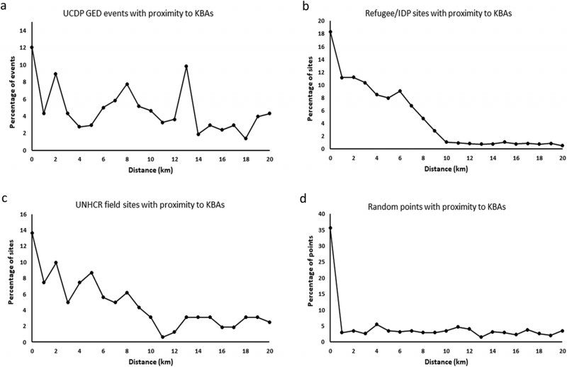
Refugee/IDP camps and UNHCR offices
The median distance of UNHCR refugee and IDP camps from KBAs was only 6.9 km, while the median distance for UNHCR field offices was 21.9 km. When compared with the average distance from random points, this indicates that UNHCR offices and refugee/IDP camps are located significantly closer to KBAs than points allocated at random. For both the refugee/IDP data and the field camps/offices there is a clear pattern in their location as regards proximity to KBAs (see Figure 2b and 2c). What we find for the three conflict data sets is that there is a tendency for increased locations in the proximity of KBAs. This is particularly notable for refugee/IDP locations up to 10 km (Figure 2b) and UNHCR field sites (Figure 2c).
These findings clearly show that the impacts of armed conflict, particularly the settlement of refugees and IDPs, are biased towards the boundaries of KBAs, thereby increasing the risk of negative impacts to these globally significant sites for biodiversity.
Georeferenced data on the location of armed conflicts and of refugee settlements/IDP camps is limited, and it is unclear how accurate the points we used are. We deliberately selected the most precise points where points were classified and believe that the patterns we show are real. However, there is a need to collate more accurate data on where conflicts are happening and the precise locations of indirect impacts of those conflicts, such as resource harvesting, pollution and, especially, the displacement of people. Not all KBAs have been identified yet; the KBAs in the WDKBA build on the Important Bird and Biodiversity Area Programme, so many of them have been triggered by the presence of bird species, but countries are being encouraged to make more comprehensive identifications of their KBAs across multiple taxonomic groups and ecosystems, and this will increase the number of KBAs. KBAs are being monitored both on the ground and remotely using remote sensing tools. This will allow conservation and potentially humanitarian actors to measure changes in KBAs, which together with more accurate georeferenced data on conflicts will allow us to assess more accurately the impacts that result from war and the displacement of people.
Case studies of KBAs in places of armed conflict
The following three case studies illustrate the different impacts on biodiversity and protected area management under conditions presented by three different types of armed conflict. They also discuss the different challenges and solutions that were used to protect biodiversity.
Case study: The Greater Virunga Landscape
The Greater Virunga Landscape presents a case study of a transboundary conservation area in Africa governed by a series of legal agreements, at times directly addressing armed conflicts afflicting its territories.40 The Greater Virunga Landscape comprises eleven contiguous protected areas, all of which are KBAs41 and many of which are recognized by other international designations, such as World Heritage Sites, Ramsar sites or biosphere reserves, affirming its environmental and cultural importance. Situated along the breathtaking spine of volcanic ranges and crater lakes of the Central Albertine Rift,42 the Greater Virunga Landscape is administered by a multi-stakeholder collaboration known as the Greater Virunga Transboundary Collaboration (GVTC) between the DRC, Rwanda and Uganda, as well as international partners. The GVTC's work began with mountain gorilla research and protection and then expanded over the decades to incorporate strategic planning, information-sharing, community development, tourism, peace and security, and more.43
Since the early 1980s, the Greater Virunga Landscape has at different times and sometimes simultaneously hosted a range of armed conflicts, including international, non-international and internationalized armed conflicts, with devastating impacts on KBAs. The most significant of these were the Ugandan Civil War in the late 1970s and 1980s, the Rwandan Civil War of 1990–94 (including the genocide against the Tutsis in 1994) and ongoing insecurity in the eastern DRC since 1996, which have collectively displaced millions of people, many of whom were settled in refugee camps in or near protected areas and were prevented from establishing secure, sustainable livelihoods due to intermittent raiding or recurring conflict displacement.44
These various forms of insecurity increase the vulnerability (and possibly desperation) of displaced peoples, along with their dependence on natural resources, many of which are situated in KBAs or other protected areas.45 The eastern DRC is home to over 4 million displaced people; 300,000 were internally displaced around the southern boundaries of Virunga National Park in February 2023 alone.46 This led to overharvesting of forests for firewood, spurring a multi-million-dollar charcoal trade alongside other exploitive natural resource economies such as mining, oil and fish; these economies are controlled by cartels composed of the region's most pernicious non-State armed groups, which frequently recruit out of settlement camps and occupy portions of protected areas. Such groups include the Democratic Forces for the Liberation of Rwanda, the March 23 Movement and the Mai-Mai militias. Historically, settlement of displaced peoples around protected areas has resulted in environmental degradation and downsizing of national parks.47 Notably, Virunga National Park has been listed as a World Heritage Site in Danger since 1994 because of the negative impacts of armed conflicts – especially due to the displacement of human populations.48
Park rangers between the three countries have worked together to deal with the impacts of war mentioned above, and others. On the ground, this cooperation has included coordinated patrols and mountain gorilla surveys, arrest and handover of cross-border poachers, information-sharing and sustained communications. As testament to these efforts, the mountain gorilla population is the only ape sub-species to improve in conservation status from critically endangered to endangered.49 In 2003, Plumptre published a study based on a staff survey of the Wildlife Conservation Society after civil wars in the DRC and Rwanda, to draw lessons on how to support conservation in armed crises, as it was evident that the places where field staff remained “fared significantly better”.50 Laying the groundwork for protected zones, local conservationists managed to secure safeguards from both the government and Rwanda Patriotic Front forces to not harm the park or mountain gorillas; a similar arrangement has been forged with other armed groups occupying the parks (e.g., gorilla protection in areas controlled by the National Congress for the Defence of the People).51 Officially, Article 44 of the DRC's Law No. 14/003 on Nature Conservation provides that “[a]ny protected area enjoys, in times of peace as well as in times of armed conflict, the necessary status of neutrality and special protection against any act likely to violate its integrity and compromise the basic principles of conservation”.52 The law also provides in Article 42 that personnel assigned to the surveillance of protected areas are “non-political and enjoy, in times of peace or armed conflict, a non-belligerent status”.53 On the ground, this neutrality has had to be reinforced through informal negotiations, including with non-State armed groups occupying the parks, and park rangers continue to be at risk.
While critically important for biodiversity, maintaining conservation activities and a presence during armed conflicts comes at great cost to individuals and families. In Plumptre's study, he recounts targeted attacks of field staff leading to the loss of 25% of the Rwandan rangers, 50% of the DRC rangers and 50% of the Karisoke Research Centre's rangers, in addition to nearly all of them being robbed at gunpoint (94%) and losing family members (88%).54 Nevertheless, Plumptre states that “field staff continued working because they felt that they were protecting an important part of their natural heritage, and they believed their work was important for their country”.55 Tragically, the Greater Virunga Landscape provides an example of the negative impacts of armed conflict on protected area defenders or park rangers. Virunga National Park, which is currently the only park publicly tracking the direct loss of lives of its rangers, reports that over 200 have been killed since 1925.56
There are numerous lessons that can be extracted from the complex and intersecting conflicts of the past and present in the Greater Virunga Landscape, but a few are worth highlighting for the purposes of this article. First is the undeniably interconnected nature of the various armed groups and the different armed conflicts they are a part of, and the KBAs. Second is the armed groups’ disregard for the boundaries of the protected areas and the individuals who protect them. Third is the large-scale human displacement and suffering that these armed occupations cause, which then magnify human dependence on natural resources for survival and could be a push factor for IDP/refugee recruitment into armed groups. Together, these issues emphasize the exigency of States operating in tandem, as they have done under the GVTC. However, such efforts are often largely driven by conservation needs, with little experience of intervening in armed conflicts or in conflict transformation, and this sometimes results in actions that are not entirely conflict-sensitive (i.e., that fail to “do no harm”).57 Also, due to lack of expertise, conservationists often rely on State armed forces for security, which would impede any potentially desired demilitarization of protected zones.58
Additionally, what this case study highlights is that in order to protect biodiversity, it is essential to protect conservation actors and displaced populations. The threats to biodiversity and safety of park rangers or other conservation actors during these times require greater support through direct physical protection, as well as sustained resources and communications.59 Displaced peoples also need to be supported through humanitarian assistance, but provided at sufficient distance from protected areas and KBAs to avoid negative ecological impacts and resort to park resources, and to prevent levels of suffering that incentivize non-State armed group recruitment. Since humanitarian assistance is typically provided where displaced peoples cluster and further displacement can be drawn to such locations, this may require assisted transportation of displaced peoples to more appropriate locations. What the three points in the previous paragraph also highlight is the difficulty of designating protected zones effectively in such complex, large-scale transboundary landscapes. While the whole of the Greater Virunga Landscape is a singular ecosystem, designating the entire territory as demilitarized would currently be impossible – there are too many armed groups operating within its bounds. While the more ad hoc site-specific approach to protected zones could be applied, and in effect has been at times for endangered species protection or humanitarian relief, this would be a temporary band-aid of inconsequential impact toward enhancing the protection of the wider ecosystem. Strengthening collaboration between conservation, humanitarian actors and local authorities may prove to be more effective, especially towards strategic planning and joint operations that can prevent environmental harms while safeguarding human security and promoting favourable protection outcomes.
Case study: South Sudan
The South Sudan case study concerns the management of designated biodiversity sites during the civil war. The partners responsible were an international NGO, Fauna and Flora International (FFI), which provided financial and technical support, with one international staff member on the ground through the civil war;60 the Ministry of Wildlife Conservation and Tourism; the South Sudan Wildlife Service; and community rangers recruited from local villages close to the protected areas. Strong local relationships had been established over a period of two years prior to the start of the civil war, and this was the only conservation programme that survived in South Sudan throughout this period.
The geographic focus is the southwestern area of South Sudan, bordering the DRC and Central African Republic – a remote, peripheral area on the borders of three conflict-affected countries. The designated wildlife protected areas are the western sector of Southern National Park (the largest in the country at 22,000 km2 and a designated KBA) and two game reserves located in the Nile watershed, a dense forested zone connecting the biomes of east and central Africa. One of these game reserves is a KBA while the other is not. This is noteworthy since it reflects the sometimes limited knowledge about protected areas in conflict-affected countries. Recent surveys61 have shown that the game reserve which was not designated as a KBA has the greater biodiversity of the two. Due to decades of armed conflict, the conservation sector was underdeveloped, meaning these protected areas had never been managed in a way recognizable today as wildlife conservation. Biodiversity baselines came from studies in the early 1980s.62 Wildlife numbers were known to have been decimated as a result of two previous civil wars, weapon proliferation and a lack of wildlife management, but the habitat remained largely intact.63
The southern region of Sudan that is now the State of South Sudan suffered civil wars in 1955–72 and 1983–2005,64 and the area of this case study was also greatly affected by the Lord's Resistance Army (LRA) between 2006 and 2010. This case study covers South Sudan's third civil war that began in 2013, the country's first as an independent nation and custodian of its own natural resources. A first peace accord was signed in August 2015 but collapsed when renewed fighting broke out in the capital Juba in July 2016. Although a revitalized peace agreement was signed in September 2018, armed conflicts continued across the country.65 This case study focuses on the period from the start of this conflict in December 2013 through 2018. This period saw an ethnically politicized, low-tech war fought largely with small arms and light weapons, the burning of villages and crops, widespread use of sexual violence, and the displacement of vast numbers of civilians, with subsequent acute food insecurity amounting to famine.66 After the initial fighting in Juba, the priority for the main parties to the conflict was to gain control of the oilfields.67 When this had been achieved, the fighting moved to timber- and mineral-rich areas, including the area of this case study. In spite of the 2018 peace agreement, conflicts continued across the country, largely fought over sub-national issues often involving control of territory and access to resources.68 Throughout the period of this case study, direct combat operations did not occur inside the protected areas of the case study. Direct military activity (by government and opposition forces alike) occurred in villages near protected areas, which directly affected those areas’ management.
Like the previous civil wars, the conflict played out along lines of government-held urban centres and opposition “rebels” fighting from the bush.69 This had a major impact on access to and control of protected areas, as “government” Wildlife Service rangers were attacked and pushed out of the rural areas by a growing local insurgency, but kinship and loyalties overlapped and remained fluid. The term “going to the bush” became a euphemism for joining the rebels. Wildlife management became fundamentally a matter of the governance of biodiversity habitat in non-neutral territory. This had serious implications for protected area managers, both international and national staff, and the perceptions of protected area management in a highly securitized environment. In this context, the first critical decision was whether FFI should remain despite the war. This decision was aided by the development of a long-term strategy (fifty-plus years) that ensured the programme could look beyond immediate difficulties and position itself for a future beyond the civil war.
In terms of protected area management, emphasis was placed on activities on the ground – i.e., that success should be measured where the biodiversity existed, especially as the central government had lost control of rural areas and therefore biodiversity protection could only be achieved locally, rather than through the efforts of a government that controlled little outside the capital city.70 Immediately after the war began and recognizing the emerging fault lines, Community Wildlife Ambassadors (CWAs, or community rangers) were recruited through the local chiefs from indigenous communities nearest the protected areas. The CWAs were trained alongside the Wildlife Service rangers and the two groups subsequently conducted management jointly, providing cooperation and collaboration across the urban/rural (government/opposition) fault line. Taking active measures to be transparent was vital because a community defence group known as the Arrow Boys had formed in this area during the LRA period and was implicated during the emergence of the local armed opposition at this time. As an organized body of mostly youths, the CWAs could have been incorrectly perceived as a threat to the government. At times, when the Wildlife Service had been fought out of its ranger posts by non-State armed groups and confined to towns, the international staff were able to continue working. This indicates that identification of neutrality (in this case, an international staff member known to all sides of the conflict by their NGO vehicle markings) can enable protected area management activities to continue.
The protected areas in this case study are located in designated “opposition” State territory, at a time when protected area designation remains subordinate to State administrative boundaries. Since the Wildlife Service is a government body, rangers are effectively operating in a conflated space, perceived as occupiers and managers of “opposition” territory. Therefore, the Wildlife Service rangers have been taught, and practice, seven fundamental rules underpinning the 1949 Geneva Conventions and their Additional Protocols of 1977 and 2005. These principles have been adapted to wildlife conservation and the handling of persons inside the protected areas, who may be poachers, hunters and/or members of non-State armed groups. The intention is to ensure the fair and non-violent handling of these individuals, many of whom are known to the rangers. This has been a critical factor for ensuring that the practice of protected areas management does not escalate tensions with local non-State armed groups, and avoids the practice of protecting biodiversity from becoming embroiled in the political conflict.
Case study: Ukraine
The ongoing Russia–Ukraine armed conflict has provided insights into the challenge that high-intensity warfare creates for efforts to protect environmentally important areas. Analysis indicates that 43% of Ukraine's designated protected areas were within 20 km of the front line during the first twelve months of the war, while at its peak, around 46% of the country's protected areas were subject to Russian control.71 Altogether, Ukraine occupies less than 6% of Europe's area, but thanks to its significance for migratory species and geographic diversity, it possesses 35% of Europe's biodiversity – more than 70,000 species, including many that are rare, relict or endemic.72 It has a relatively well-developed network of terrestrial protected areas, although at around 13% coverage this is well below the European Union average of 26.4%. Generally, Ukraine's protected area management is underdeveloped.73
The military characteristics of the war have strongly influenced its impact on protected areas, a number of which have become the focus of fighting. These have included the Chernobyl Exclusion Zone, part of the wider Polesia landscape bordering Belarus in the north, the fragile Kinburn Peninsula and coastal reserves (a KBA) in proximity to the UN Educational, Scientific and Cultural Organization (UNESCO) Black Sea Biosphere Reserve in the south, and the Holy Mountains National Park near Lyman in the east. In each case, human-made and natural features in these areas were perceived as being of strategic or tactical value. This was the case at the former Chernobyl nuclear plant, for Kinburn's proximity to the southern cities of Kherson and Mykolaiv, and for forest cover around an important rail junction in the case of Lyman. Moreover, the status of terrestrial and marine protected areas has received little attention in the public narrative around incidents that have affected these areas, such as that of Snake Island (Zmiinyi Island) in the Black Sea.74
While comprehensive data on the impacts on species and habitats is unavailable at the time of writing as the conflict is ongoing, a range of issues have been reported by researchers on the ground. These include damage to woodlands and cratering from the use of explosive weapons, increased rates of landscape fires at the firing and impact points of heavy weapons, the destruction and looting of protected area buildings, displacement of staff and researchers, and acoustic and chemical pollution in terrestrial and marine habitats.75
Although environmentally relevant negotiations took place during the first twelve months of the armed conflict, including over a demilitarized zone around the Zaporizhzhia nuclear plant76 and the Black Sea Grain Corridor initiative,77 the speed, scale and intensity of the war have generally precluded discussion between the parties on the protection of nature per se. This perhaps suggests greater emphasis on the value of reaching agreement for protected zones prior to the outset of high-intensity international armed conflicts. Nevertheless, the armed conflict has suggested other means through which biodiversity protection could be enhanced in such contexts, even in the absence of protected zone agreements or failures in their implementation.
The first relates to the visibility of harms. A combination of remote monitoring methodologies, the activities of domestic and international civil society, and energetic government advocacy mean that the environmental dimensions of the armed conflict have been comparatively well documented.78 Coverage has included regular updates from the Ukrainian Ministry of the Environment and the Protection of Natural Resources,79 domestic and international media interest in the circumstances of Ukrainian conservationists,80 and collaborative advocacy by scientists aimed at drawing attention to the damage being caused to protected areas, as well as to the wider environmental consequences of domestic governance changes in response to martial law.81 Visibility for the consequences of the armed conflict on ecologically important areas is an important component of ensuring that harm will be addressed during recovery. This objective will be aided by the development of a more comprehensive digital data set of ecologically important areas,82 which could be used to help inform recovery processes. including humanitarian mine action.
The armed conflict has created considerable challenges for Ukrainian conservationists: in addition to access and security constraints, individual conservationists have joined the armed forces, while conservationist groups have faced the curtailment of projects and programmes and have lost valuable data sets that existed only in written form.83 Technical and financial support from domestic and international civil society has been extremely valuable, whether from the Ukrainian diaspora or from NGOs, academic institutions or regional intergovernmental organizations with a conservation mandate, such as the Agreement on the Conservation of Cetaceans of the Black Sea, Mediterranean Sea and Contiguous Atlantic Area (ACCOBAMS).84 Conservation organizations such as the Frankfurt Zoological Society, a historically active partner in projects in Ukraine, have reoriented their activities in response to the armed conflict; this has included arranging the housing of 800 IDPs in park accommodation, implementing new partnerships with organizations working in the most affected regions, and supporting the procurement of supplies necessary for the running of protected areas.85 Technical and financial support, as well as capacity-building, will continue to be important, but such responses to armed conflicts are typically ad hoc and could benefit from standing capacity and expertise informed by an assessment of domestic conservation needs in areas affected by armed conflict.
A third area that should be addressed is the loss of conservation areas due to military activities during armed conflicts. Between 2014 and 2022, protected area authorities in Ukraine lost control of 6% of their protected areas in Crimea and the eastern Donbas region, which represented 12% of the country's total by area, including marine protected areas.86 Some of these areas have been turned over to military training areas; park facilities have reportedly been looted, and some have suffered more severe landscape fires due to constraints on firefighting response.87 While some sources claim that some degree of environmental governance is being sustained,88 the true extent of protected area management is unclear. This emphasizes the challenge of sustaining conservation governance and the integrity of protected areas in the midst of active armed conflict, and thus the value of designating protected zones in ways that allow for the continuation of conservation activities.
Recommendations addressing the establishment of KBAs and protected areas as environmental protected zones
Historical and contemporary debate over the designation of protected zones has tended towards formal designations under the applicable international law. However, as outlined in this article, the conditions and circumstances faced by national and local authorities, communities and conservation organizations across the cycle of conflicts are so diverse as to likely preclude any single formal model. Moreover, in many cases protection is underdeveloped even before the onset of insecurity or conflict. Nevertheless, protection can take many forms. We have identified three areas that stakeholders should focus on to enhance the protection of areas of environmental importance in relation to armed conflicts: (1) protection through visibility, (2) protection through local stakeholders and (3) protection through international stakeholders.
Protection through visibility
While data on the boundaries and values of areas of environmental importance is growing, it should not be viewed as complete. In many cases, targeted work will be needed to better document areas threatened by armed conflict, including occupation; this includes the digitization of physical records that may be at risk of loss. Conservation experts in conflict-affected areas will benefit from international assistance in preparing up-to-date digital maps that help define both formal protected areas and ecologically important areas that would benefit from protection. As much as possible, conservation actors should work with States before conflicts occur to formally recognize KBAs as protected zones and to provide protocols for permissible and non-permissible activities during armed conflict. With a few exceptions for high-profile species, biodiversity protection during conflict remains a low priority and advocacy is foundational to ensuring stakeholder attention on the need to protect areas. One important component of this is ensuring that harm can be monitored during conflicts. In many cases this may involve remotely gathered data, such as on fires or deforestation, yet determining the precise impact on species and habitats typically requires ground surveys that are contingent on the security conditions, making delays in understanding impacts likely. Collaboration with local expertise is important for ground-truthing and contextualizing remote observations.
Further research is needed on the drivers of damage to ecologically important areas in relation to armed conflicts. In this article, we identified a relationship between the location of displacement camps and KBAs; this is a clear example of how increased visibility and data could improve protection. We recommend that humanitarian actors collate geospatial data on the locations of (1) camps and associated infrastructure, (2) local conflict hotspots and (3) where natural resources are being obtained to sustain the camps. These data should be maintained together with protected area and KBA data layers, available for free from the World Database of Protected Areas and the WDKBA respectively, in order to proactively assess the potential impact of humanitarian operations on biodiversity. While camps may draw in natural resources from far wider geographic areas at times, simple awareness-raising steps such as these could help embed biodiversity considerations at the local level, and within humanitarian organizations.
Once established, refugees and other displaced people tend to move to where relief centres and camps are providing assistance. Ideally the planning of these sites should consider the biodiversity of the region. However, because such sites are often established on plots of land provided by governments or donated by local community members, advocacy may need to be addressed on multiple levels with a range of stakeholders in order to minimize environmental impacts.
Humanitarian actors should also investigate ways in which sensitive data on the locations of their operations can be used to support the monitoring of the impacts of conflicts on protected areas and KBAs in the future. This may be through internal impact assessments or through the development of dedicated partnerships with conservation actors active in these areas and the IUCN, which also provides scientific and technical advice on UNESCO World Heritage Sites in Danger. Environmental staff operating under or in collaboration with humanitarian organizations – for example, environment officers or settlement planners under UNHCR, the UN Environment Programme or the UN Satellite Centre – should be tasked with monitoring these impacts.
We recommend that the wider humanitarian and conservation sectors collaborate and initiate discussions to explore and identify best practice in collating and sharing data. These discussions should consider what is and is not feasible within the security constraints in which these sectors operate, what data is currently collected, and how that data might be used in the future to understand and mitigate the impact of humanitarian activities on environmentally sensitive areas.
Protection through local stakeholders
Enhancing protection is impossible without contextual and situated knowledge. The vast majority of ecologically important areas have long histories of use by local communities, understanding of which is important to address pre-existing stresses and emergent pressures linked to armed conflicts. Community participation is an important component in conservation, particularly in areas where ecological pressures or distrust are high, and especially during times of conflict.89 Sustainable and effective interventions demand conflict-sensitive approaches, for which there is a growing body of best practice.90 Local conservation actors may benefit greatly from external technical expertise, particularly as their community roles change in response to the conditions forced on them by war (such as in the South Sudan case). This may be particularly true where conservationists are faced with balancing humanitarian needs resulting from conflict with ecological protection in the areas where they work. Interventions to protect biodiversity during the cycle of armed conflict should maintain the principle of subsidiarity or local and community-led conservation governance as the long-term solution.
There can be a significant blurring of lines between local communities, non-State armed groups, protected area managers and State armed actors. Local communities nearest the protected areas may be linked to political processes, and in many protected areas, non-State armed groups are important actors (as in the South Sudan and Greater Virunga Landscape cases). Guidance on managing relationships between conservation actors and armed actors could be beneficial.91 Whether during hostilities or under occupation, pre-existing governance and security structures may mean that protected areas cannot be viewed as politically neutral or demilitarized spaces, complicating efforts to present conservation actors as neutral participants. This is problematic as neutrality, or the perception of it, can be highly beneficial for conservation workers.
In these circumstances, “neutral” conservation actors become key arbiters of the conservation activities that can be undertaken. Formal recognition of their neutrality, on their person (such as armbands) and on vehicles and infrastructure, could be beneficial. As noted in the Greater Virunga Landscape case study, Law No. 14/003 provides for the neutrality of protected areas and the non-belligerent status of their personnel, which under Article 43 are identified by their “uniforms with distinctive signs and ranks”.92 However, ranger uniforms alone have not been sufficient to protect park personnel from becoming victims of armed conflicts. Also, if not all KBAs or protected areas are designated as protected zones, there may be a need to further distinguish personnel operating in protected zone KBAs and parks. In terms of activities during armed conflict, the monitoring of biodiversity, the legal maintenance of protected zone boundaries, and capacity development may be some of the more helpful and least antagonizing (i.e., conflict-insensitive) activities. This highlights that biodiversity conservation itself needs to be upheld as the “neutral” entry point, an activity that should be developed during the pre-conflict period. This will be essential for negotiating with all sides of a conflict. Protection activities need to adapt to the dynamics of armed conflict, including the careful return of normal rules and regulations for the management of protected areas, which may involve greater restrictions than during the war itself as much of the protected area downgrading, downsizing and degazettement can occur post-conflict.
We recommend that the humanitarian sector, States and international conservation bodies cooperate in support of the recognition of conservationists as neutral actors in armed conflict, for example through the use of a recognizable armband and flag. The humanitarian sector can also help identify and inform the development of best practices on managing relationships between conservation actors and armed actors with specific guidelines on permissible types of engagement within protected zones and/or use of arms for conservation purposes (such as protected area law enforcement or providing security for conservation actors).
Protection through international stakeholders
The last decade has seen a significant shift in attitudes towards the importance of environmental protection in relation to armed conflicts. Increased documentation and growing global attention on accelerating biodiversity loss and on the potential role of nature in peacebuilding and post-conflict recovery are also creating the conditions for a reappraisal of how areas of environmental importance can be protected. Change will require a multi-level approach. As with donors in other sectors, the foundations and private donors often associated with funding conservation programmes will need to be persuaded that the potential returns from work in insecure and conflict-affected areas outweigh the perceived risks, a process that can be aided by developing conflict-sensitive programming policies.93 Given the current failings in financing climate adaptation in such settings, this will likely require dedicated and focused advocacy on the considerable benefits of such work, such as its contribution to environmental peacebuilding. International conservation organizations need to increase their engagement in fragile and conflict-affected areas to ensure that technical and operational knowledge, along with best practice, is collated and shared and can be made available to those who would benefit from it in response to crises. International stakeholders also have an important role to play in drawing attention to the relationship between armed conflict and biodiversity loss.94 This is particularly important given the reluctance within some multilateral environmental agreements to address what can be viewed as politically contentious security issues. These attitudes reinforce siloed approaches that prevent progress on mainstreaming peace and security considerations in biodiversity instruments, such as the CBD. Mainstreaming should be cross-cutting – for example, also addressing biodiversity loss in security instruments on the proliferation of small arms and light weapons, or in humanitarian mine action.
We recommend that humanitarian organizations, particularly those with UN observer status and signatories to the Climate and Environment Charter for Humanitarian Organizations, collectively advocate to strengthen global policy and to ensure that the multilateral environment, humanitarian and development agendas are better aligned to safeguard biodiversity and areas of environmental importance.95 These organizations could engage with the secretariats of multilateral environmental agreements, outline protected zone protocols for humanitarian actors and support the development of conflict-sensitive rules of engagement for international donors and actors.
These three priority areas are not exhaustive but if implemented would enhance the identification, profile and protection of ecologically important areas affected by armed conflicts. A final consideration is whether such efforts can be left to happen organically, or whether they would be better catalysed by a formal international instrument or a more informal multi-stakeholder process. In our view, a history of under-prioritization, the accelerating crisis of global biodiversity loss, and the ecological, livelihood and climate benefits that could accrue suggest that progress is too important to leave to chance. The designation of environmental protected zones should not be left to ad hoc arrangements once conflict activities are under way, and they need to do more than simply delineate no-go zones that exist only on paper.
- 1UNGA Res. 77/04, “Protection of the Environment in Relation to Armed Conflicts”, 9 December 2022.
- 2UN Environment Programme (UNEP), Kunming-Montreal Global Biodiversity Framework, Decision Adopted by the Conference of the Parties to the Convention on Biological Diversity, UN Doc. CBD/COP/DEC/15/4, 19 December 0.
- 3UN Framework Convention on Climate Change, “What Is the Triple Planetary Crisis?”, 1 April 2022, available at: https://unfccc.int/blog/what-is-the-triple-planetary-crisis (all internet references were accessed in April 202).
- 4Jianchu Xu and David R. Melick, “Rethinking the Effectiveness of Public Protected Areas in Southwestern China”, Conservation Biology, Vol. 21, No. 2, 2007.
- 5Nigel Dudley (ed.), Guidelines for Applying Protected Area Management Categories, International Union for Conservation of Nature (IUCN), Gland, 2008.
- 6Gerardo Budowski, “Peace through Parks”, Our Planet, Vol. 14, No. 4, 2004.
- 7ILC, Text and Titles of the Draft Principles Provisionally Adopted by the Drafting Committee on First Reading, UN Doc. A/CN.4/L.93, 6 June 2019, Principles 4 and 18.
- 8ILC, Report of the International Law Commission: Sixty-Eighth Session, UN Doc. A/71/10, Supp. 10, 2016.
- 9ILC, Draft Principles on Protection of the Environment in Relation to Armed Conflicts, with Commentaries, UN Doc. A/77/10, 2022.
- 10IUCN, A Global Standard for the Identification of Key Biodiversity Areas, Version 1.0, 2016, p. 8.
- 11Ibid., p. 9; see also the Key Biodiversity Area Partnership website, available at: www.keybiodiversityareas.org/.
- 12IUCN, above note 10.
- 13Elaine C. Hsiao, “Protecting Protected Areas in Bello: Learning from Institutional Design and Conflict Resilience in the Greater Virunga and Kidepo Landscapes”, Goettingen Journal of International Law, Vol. 10, No. 1, 2020.
- 14Gary Machlis and Thor Hanson, “Warfare Ecology”, BioScience, Vol. 58, No. 8, 2008.
- 15Christopher Mitchell, The Nature of Intractable Conflict: Resolution in the Twenty-First Century, Palgrave Macmillan, London, 2014, pp. 28–30.
- 16Linsey Cottrell, EU Military Greening Policies: A Review of Transparency and Implementation, Conflict and Environment Observatory (CEOBS), January 2023; UNEP, Greening the Blue Helmets: Environment, Natural Resources and UN Peacekeeping Operations, May 2012.
- 17Kaitlyn M. Gaynor et al., “War and Wildlife: Linking Armed Conflict to Conservation”, Frontiers in Ecology and the Environment, Vol. 14, No. 10, 2016.
- 18Ibid., Table 1, provides a useful comparison of pathways through which armed conflict affects wildlife.
- 19Jay E. Austin and Carl Bruch (eds), The Environmental Consequences of War: Legal, Economic, and Scientific Perspectives, Cambridge University Press, Cambridge, 2000.
- 20K. M. Gaynor et al., above note 17.
- 21Ibid.
- 22José Carlos Brito et al., “Armed Conflicts and Wildlife Decline: Challenges and Recommendations for Effective Conservation Policy in the Sahara-Sahel”, Conservation Letters, Vol. 11, No. 5, 2018; Franciany Braga-Pereira, Juliano André Bogoni and Rômulo Romeu Nóbrega Alves, “From Spears to Automatic Rifles: The Shift in Hunting Techniques as a Mammal Depletion Driver during the Angolan Civil War”, Biological Conservation, Vol. 249, September 2020.
- 23Thor Hanson et al., “Warfare in Biodiversity Hotspots”, Conservation Biology, Vol. , No. 3, 2009.
- 24Karen Büscher, “African Cities and Violent Conflict: The Urban Dimension of Conflict and Post Conflict Dynamics in Central and Eastern Africa”, Journal of Eastern African Studies, Vol. 12, No. 2, 2018.
- 25International Crisis Group, Containing Militancy in West Africa's Park W, Africa Report No. 310, 26 January 2023.
- 26ILC, above note 9, pp. 154–155.
- 27John Hatton, Mia Couto and Judy Oglethorpe, Biodiversity and War: A Case Study of Mozambique, Biodiversity Support Program, 2001.
- 28Nelson Grima and Simron J. Singh, “How the End of Armed Conflicts Influence[s] Forest Cover and Subsequently Ecosystem Services Provision? An Analysis of Four Case Studies in Biodiversity Hotspots”, Land Use Policy, Vol. 81, February 2019.
- 29Rupert Smith, The Utility of Force: The Art of War in the Modern World, Vintage Books, New York, 2008, pp. 267–269.
- 30David Kilcullen, Out of the Mountains: The Coming of Age of the Urban Guerrilla, Hurst, London, 2015.
- 31Adrian Garside, “Achieving Effective Biodiversity Protection during War and Armed Conflict”, RUSI: Forward Look, 10 December 2021.
- 32Author interviews with Ministry of Interior and Wildlife Conservation, Juba, 2014 (on file with authors).
- 33For example, in South Sudan and Southern Sudan prior to independence, the Wildlife Service held a dual role as manager of the protected areas and as one component of the “organized forces” with security duties alongside the army, police, prison and fire services.
- 34Author interview with Jody Bragger, Tellus Reserves, Oxford, October 2022 (on file with authors).
- 35Esther Marijnen, “Public Authority and Conservation in Areas of Armed Conflict: Virunga National Park as a ‘State within a State’ in Eastern Congo”, Development and Change, Vol. 49, No. 3, 2018.
- 36For example, Fauna and Flora International (FFI) worked across the conflict fault line in South Sudan's civil war.
- 37World Bank, Collaborative Management Partnership Toolkit, 2021.
- 38See “Uppsala Conflict Data Program (UCDP)”, Demscore, available at: www.demscore.se/partners/ucdpviews/.
- 39BirdLife International, World Database of Key Biodiversity Areas, developed by the KBA Partnership: BirdLife International, IUCN, Amphibian Survival Alliance, Conservation International, Critical Ecosystem Partnership Fund, Global Environment Facility, Re:wild, NatureServe, Rainforest Trust, Royal Society for the Protection of Birds, Wildlife Conservation Society and World Wildlife Fund, 2023, available at: www.keybiodiversityareas.org/.
- 40Elaine C. Hsiao, “Nomoscaping Peace in Times of Conflict: A Case Study of the Greater Virunga Transboundary Collaboration (GVTC)”, IUCN AEL E-Journal, No. 9, 2018.
- 41S. Ayebare et al., Identifying Climate-Resilient Corridors for Conservation in the Albertine Rift, unpublished report to MacArthur Foundation, Wildlife Conservation Society, 2013.
- 42Andrew Plumptre et al., The Biodiversity of the Albertine Rift, Albertine Rift Technical Report No. 3, Wildlife Conservation Society, 2003; Anton Seimon and Andrew Plumptre, “Albertine Rift, Africa”, in Jodi A. Hilty, Charles C. Chester and Molly S. Cross (eds), Climate and Conservation: Landscape and Seascape Science, Planning and Action, Island Press, Washington, DC, 2012.
- 43GVTC, “Transboundary Collaboration in the Greater Virunga Landscape Protected Area Network: Transboundary Strategic Plan 2013–2018”, March 2014; GVTC, Greater Virunga Landscape: Annual Conservation Status Report 2015, Kigali, March 2017; GVTC Secretariat, “Coordinated Patrols, the Right Ancestor of Greater Virunga Transboundary Collaboration”, 9 March 2023, available at: https://greatervirunga.org/coordinated-Patrols-the-right-ancestor-of-gr….
- 44Kenneth Omeje and Tricia Redeker Hepner (eds), Conflict and Peacebuilding in the African Great Lakes Region, Indiana University Press, Bloomington, IN, 2013.
- 45Juichi Yamagiwa, “Bushmeat Poaching and the Conservation Crisis in Kahuzi-Biega National Park, Democratic Republic of the Congo”, Journal of Sustainable Forestry, Vol. 16, No. 3–4, 2008.
- 46UNHCR, Operational Update: Democratic Republic of the Congo, February 2023, February 2023.
- 47Samuel Kanyamibwa, “Impact of War on Conservation: Rwandan Environment and Wildlife in Agony”, Biodiversity and Conservation, Vol. 7, No. 11, 1998.
- 48UN Educational, Scientific and Cultural Organization (UNESCO), World Heritage Committee: Eighteenth Session, UN Doc. WHC-94/CONF.003/16, 31 January 1995.
- 49IUCN, “Mountain Gorilla”, IUCN Red List, 2023.
- 50Andrew J. Plumptre, “Lessons Learned from On-the-Ground Conservation in Rwanda and the Democratic Republic of the Congo”, Journal of Sustainable Forestry, Vol. 16, No. 3–4, 2003, p. 71.
- 51Ibid., p. 70; “Interview with General Laurent Nkunda”, YouTube, 3 January 2009, available at: www.youtube.com/watch?v=K9tiu-1ig58.
- 52DRC, Law No. 14/003 on Conservation of Nature, 11 February 2014, Art. 44.
- 53Ibid., Art. 42.
- 54A. J. Plumptre, above note 50, p. 80.
- 55Ibid., p. 70.
- 56Virunga National Park, “Virunga's Rangers: Guardians of Biodiversity”, 2023, available at: https://origins.virunga.org/about/rangers/.
- 57Elaine Hsiao and Philippe Le Billon, “Connecting Peaces: TBCAs and the Integration of International, Social, and Ecological Peace”, International Journal on World Peace, Vol. 37, No. 4, 2021.
- 58E. C. Hsiao, above note 13.
- 59A. J. Plumptre, above note 50.
- 60This case study is based on empirical data from the authors’ participant/observer research.
- 61Surveys using remote-sensing cameras, conducted by FFI, Bucknell University and the South Sudan Wildlife Service: see “‘Forgotten Forests’ of South Sudan: Camera Traps Capture First-Ever Pictures of Forest Elephants, Giant Pangolins in the Country”, Mongabay, 9 December 2015, available at: https://news.mongabay.com/2015/12/forgotten-forests-of-south-sudan-came….
- 62See e.g. Luigi Boitani, The Southern National: A Master Plan, Institute of Zoology, Faculty of Sciences of the University of Rome, 1981; Jesse C. Hillman, Ecological Survey and Management Recommendations for Bangangai Game Reserve, South West Sudan, with Special Reference to the Bongo Antelope, New York Zoological Society, March 1983.
- 63UN Development Programme, “Launching Protected Area Network Management and Building Capacity in Post-Conflict Southern Sudan”, 2010.
- 64Douglas H. Johnson, South Sudan: A New History for a New Nation, Ohio University Press, Athens, OH, 2016.
- 65Intergovernmental Authority on Development, Revitalised Agreement on the Resolution of the Conflict in the Republic of South Sudan (R-ARCSS), 12 September 2018.
- 66Commission on Human Rights in South Sudan, “There is Nothing Left for Us”: Starvation as a Method of Warfare in South Sudan, UN Doc. A/HRC/45/CRP.3, 5 October 2020.
- 67This is based on numerous UN Mission Daily Situation Reports on the conflict at that time, and interviews with expat security staff working in the oil sector. At independence, an estimated 94% of South Sudan's revenue came from oil; the oilfields existed in the most politically contended areas.
- 68See, for example, David K. Deng, Land Governance and the Conflict in South Sudan, London School of Economics and Political Science, Conflict Research Programme, October 2021.
- 69Interview with Gerard Prunier in Vincent Hugeaux, “Comprendre la guerre suicidaire au Soudan du Sud”, L'Express, 8 January 2014.
- 70This decision on programmatic approach was made by the authors with the agreement of FFI staff member Matt Rice.
- 71CEOBS and Zoï Environment Network, “Ukraine Conflict Environmental Briefing 5: The Coastal and Marine Environment”, 2 January 2023.
- 72CBD, “Country Profiles: Ukraine”, available at: www.cbd.int/countries/profile/?country=ua.
- 73CBD Secretariat and UNDP, Aichi Biodiversity Target 11 Country Dossier: Ukraine, 2021.
- 74CEOBS and Zoï Environment Network, above note 71.
- 75Kateryna Polyanska, “Impact of Military Action on Ukraine's Wild Nature”, Ukraine War Environmental Consequences Work Group, 30 January 2023, available at: https://uwecworkgroup.info/impact-of-military-action-on-ukraines-wild-n….
- 76International Atomic Energy Agency, “Update 152 – IAEA Director General Statement on Situation in Ukraine”, 30 March 2023, available at: www.iaea.org/newscenter/pressreleases/update-152-iaea-director-general-….
- 77UN, “Joint Coordination Centre for the Black Sea Grain Initiative”, available at: www.un.org/en/black-sea-grain-initiative/background.
- 78Doug Weir, “Sustainable Recovery? First Sustain Interest in Ukraine's Environment”, CEOBS, 28 July 2022, available at: https://ceobs.org/sustainable-recovery-first-sustain-interest-in-ukrain….
- 79For an archive of the Ministry of Environmental Protection and Natural Resources of Ukraine's weekly updates on environmental issues linked to the armed conflict, see: https://tinyurl.com/yc8juhf7.
- 80Antonia Cundy, “Dead Dolphins: How Nature Became Another Casualty of the Ukraine War”, The Guardian, 6 July 2022.
- 81Ukrainian Nature Conservation Group, “About Us”, available at: https://uncg.org.ua/en/about-us/; Ukraine War Environmental Consequences Work Group, “About UWEC”, available at: https://uwecworkgroup.info/about/.
- 82Linas Svolkinas, Oleksiy Vasyliuk and Dmytro Averin, “Mapping Ukraine's Ecologically Important Areas”, CEOBS, 18 October 2023, available at: https://ceobs.org/mapping-ukraines-ecologically-important-areas/.
- 83Ibid.
- 84ACCOBAMS, “Introduction”, available at: https://accobams.org/about/introduction/.
- 85Frankfurt Zoological Society, “Support for protected areas in the Carpathians”, available at: https://fzs.org/en/support/support-for-protected-areas-in-the-carpathia….
- 86Oleksii Vasyliuk, “Nine Years After Crimea's Annexation: Militarization's Environmental Consequences”, Ukraine War Environmental Consequences Work Group, 13 March 2023; CEOBS and Zoï Environment Network, above note 71.
- 87Dmitry Simonov, “A Million Wild Orchids and a Bird Sanctuary: What the War Is Doing to the Kinburn Spit”, Ukrainska Pravda, 15 January 2023, available in Ukrainian at: www.pravda.com.ua/articles/2023/01/15/7383288/.
- 88Olga Shashkina, “Exploring Environmental Governance in Eastern Ukraine”, CEOBS, 21 May 2020.
- 89Nabin Baral, “Institutional Resilience of Community-Based Conservation to the Maoist Insurgency in Nepal”, doctoral diss., Virginia Polytechnic Institute and State University, 2 November 2009.
- 90Nora Moraga-Lewy and Janet Edmond, Conflict Sensitivity and Environmental Peacebuilding in Conservation: Lessons Learned from Conservation International, Conservation International, 9 December 2022.
- 91See e.g. Leo Braack et al., Security Considerations in the Planning and Management of Transboundary Conservation Areas, IUCN, 2006.
- 92Law No. 14/003, above note 52, Art. 43.
- 93Global Environment Facility, Evaluation of GEF Support in Fragile and Conflict-Affected Situations, GEF/E/C.59/01, Independent Evaluation Office, 11 November 2020.
- 94Henrike Schulte to Bühne, “Do Mention the War: Why Conservation NGOs Must Speak Out on Biodiversity and Conflicts”, CEOBS Law and Policy, 11 April 2020, available at: https://ceobs.org/do-mention-the-war-why-conservation-ngos-must-speak-o….
- 95Climate and Environment Charter for Humanitarian Organizations, 2021, available at: www.climate-charter.org/.